2.7 Raster
The book will focus on regular grids, ie cell with constant size. Other grids exist.
The raster data model consists:
an header with CRS, extent (cols, rows, cell size), origin (usually lower left)
a matrix
Raster does not need to store CRS at every cell or at the four corner -> faster processing but a cell can only contains a single value.
2.7.1 R packages for raster data
- {raster} -> {terra}:
- focus on regular grid,
- one or multi-layered rasters,
- uses C++ or C++ pointers,
- uses its own vector data model,
- rely on built-in function that works on its objects
- focus on regular grid,
- {stars}:
- manage also other grids,
- raster data cubes,
- stars store value has list of array or file path to large one,
- rely on sf for vector,
- built-in function + methods for existing R functions
In both cases:
raster should have the same extent
raster can be read in memory / just the metadata
You can convert from one to an other (st_as_stars() or rast()).
2.7.2 Introduction to terra
Like sp you can still find a lot of raster. terra offer backward compatibility.
terra has the option to divide big raster in smaller chunks.
raster_filepath = system.file("raster/srtm.tif", package = "spDataLarge")
my_rast = rast(raster_filepath)
class(my_rast)
## [1] "SpatRaster"
## attr(,"package")
## [1] "terra"my_rast## class : SpatRaster
## dimensions : 457, 465, 1 (nrow, ncol, nlyr)
## resolution : 0.0008333333, 0.0008333333 (x, y)
## extent : -113.2396, -112.8521, 37.13208, 37.51292 (xmin, xmax, ymin, ymax)
## coord. ref. : lon/lat WGS 84 (EPSG:4326)
## source : srtm.tif
## name : srtm
## min value : 1024
## max value : 2892ext(my_rast)## SpatExtent : -113.239583212784, -112.85208321281, 37.1320834298579, 37.5129167631658 (xmin, xmax, ymin, ymax)inMemory(my_rast)## [1] FALSE# help("terra-package")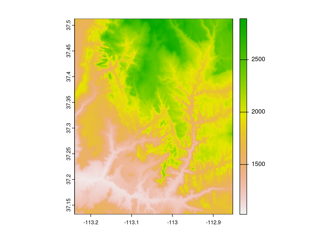
2.7.4 Raster classes
terra also uses GDAL for reading/writing.
rast() can create raster from scratch:
new_raster = rast(nrows = 6, ncols = 6,
                  xmin = -1.5, xmax = 1.5, ymin = -1.5, ymax = 1.5,
                  vals = 1:36)
SpatRaster can also deals with multiple layers:
multi_raster_file = system.file("raster/landsat.tif", package = "spDataLarge")
multi_rast = rast(multi_raster_file)
multi_rast
## class : SpatRaster
## dimensions : 1428, 1128, 4 (nrow, ncol, nlyr)
## resolution : 30, 30 (x, y)
## extent : 301905, 335745, 4111245, 4154085 (xmin, xmax, ymin, ymax)
## coord. ref. : WGS 84 / UTM zone 12N (EPSG:32612)
## source : landsat.tif
## names : landsat_1, landsat_2, landsat_3, landsat_4
## min values : 7550, 6404, 5678, 5252
## max values : 19071, 22051, 25780, 31961nlyr(multi_rast)## [1] 4they can be subset:
multi_rast3 = subset(multi_rast, 3)
multi_rast4 = subset(multi_rast, "landsat_4")
And combine:
multi_rast34 = c(multi_rast3, multi_rast4)As raster are usualy not stored .rds/.rda are not an option to store them. We can:
wrap()/unwrap()to save the reference objectwriteRaster()